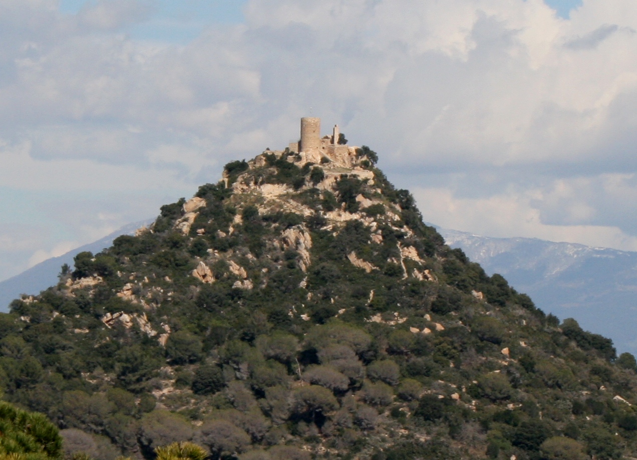
The Oppidum
Archaeologists have identified up to 5 phases of occupation at the oppidum of Burriac over the extensive period that ran from the 6th c. B.C.E. to the first half of the 1st c. B.C.E. Because our project focuses on a concrete chronological period of time (2nd – 1st century B.C.E.) when the process of Roman colonization took place, here we will only describe the last three habitation phases of the oppidum.
The Oppidum At Burriac
Phase III. Last quarter of the 4th c. B.C.E. and 3rd c. B.C.E.
During this phase, the population center that had grown up from the Bronze Age onwards on the southern hillside of Burriac finally developed into a well-planned oppidum. The relevant communal architecture suggests the consolidation of a strong political power. In this period, the oppidum was given a complex and coherent defensive system. The main feature and most significant element of which is a perimeter wall — parts of which date to the last quarter of the 4th c. B.C.E. — with clear defensive characteristics, such as the inclusion of a number of towers, including those on the East, all on square foundations.
There are also simple domestic structures — which probably make up the largest component of the site at this time — near the wall and the tower in the eastern part of the Iberian town, often attached to the base of the wall. The only dating indication that could be established for these structures is of their abandonment, at an undetermined date in the last quarter of the 3rd c. B.C.E. The structures in the central section of the oppidum also seem to date to the 3rd c. B.C.E. Thus, at least a section of the Iberian town was already constructed by this time.
Burriac urban development and the creation of an important defensive system show that the oppidum had become the center of a hierarchically organized territory. These changes are reflected in political, economic, social and cultural developments instituted by the subsequent colonization process, in phases IV and V, during which the oppidum reached the peak of its importance, before being abandoned in the first half of the 1st c. B.C.E.
Phase IV. Second half of the 2nd c. B.C.E.
There is little archaeological and historical information regarding the first half of the 2nd c. B.C.E., but the picture becomes clearer for the second half of the century, during which there was major restructuring, with important urban and demographic developments, both in the oppidum at Burriac and in the valley in general. It is difficult not to relate this to well-known historical events, such as the Romans’ arrival at Emporion during the Second Punic War (218 B.C.E.), the indigenous uprising of 197 B.C.E., and its subsequent repression by Cato — which most likely brought phase III to an end — and the construction of the late Republican settlement in the Cabrera de Mar valley.
In terms of urban development and architecture, the remodeling of Burriac brought together an assortment of new construction techniques and materials that originated in the Italian peninsula — such as the use of tegulae and imbrices, dolia, and pavements in opus signinum — which had never before been used by the Iberians, alongside the continued use of a number of local techniques.
However, the urban remodeling of Burriac goes further than the simple adoption of Italic techniques or materials. The construction, or reconstruction, of key structures of the oppidum included the remodeling of the southern gate, using a technique very similar to Roman opus quadratum, which was clearly aimed at providing the settlement with a monumental main access. The dolia area, which was probably dedicated to wine storage, is conspicuous because of its large size — at least 17 dolia —, and because its function, whether commercial or industrial, seems to go beyond the private sphere.
In contrast to the communal function of this new space, it is important to highlight the presence of a group of storage pits that were filled in during the current and following phase. These are single pits, dug inside the walls of domestic spaces: pits 36 and 37 are good examples. They seem to indicate that a private storage system, based on the domestic unit, may have become the norm during the final phases of the oppidum. Such private control of some of the available resources contrasts with larger-scale, generalized storage and redistribution systems, such as the dolia store.
Even more important than these developments was the explosion of imported — essentially Italic — material culture, which shows that the Iberian settlement had again become an important center for commerce and redistribution, control of the territory of the Laietani, as well as Northeastern Iberia in general, following the rather unclear phase in the first half of 2nd c. B.C.E.
Phase V. 1st half of the 1st c. B.C.E.
During this final phase, the oppidum appears to have been gradually and peacefully abandoned, without any sign of war or any other traumatic event. The first signs of abandonment appear during the early 1st c. B.C.E., more precisely, around the years 100-90 B.C.E., and involve the oppidum’s cistern and a good number of domestic units. A second phase of abandonment occurred around 80-70 B.C.E., when a large number of structures, including a further group of houses and the dolia warehouse, were abandoned. The cistern would be later used as a rubbish dump. Although a small inhabited core remained, it seems evident that everything that had characterized the major and strongly hierarchal urban core of the early phase of the second half of the 2nd c. B.C.E. — which functioned as an important redistribution center — has now changed. It is extremely significant that the late Republican settlement established at the foot of Burriac hill during the second half of the 2nd c. B.C.E. was also abandoned during the first quarter of the 1st c. B.C.E., paralleling the foundation, ex novo, of the new city of Iluro, recently dated to 80/70 B.C.E. It is part of a major reorganization that initially affected northeast Spain, but then spread throughout Spain.
Despite the decline of the Iberian town of Burriac, certain dynamism, together with some retention of population, is still seen in some sectors of the settlement during the early stages of abandonment (90-70 B.C.E.), when it seems that some parts of the town were still in use. There is evidence of renovation in the central sector, during which at least one new building was constructed, and for the opening of a new street.
On the basis of the latest habitation levels in Burriac it would appear that a residual population remained active until the mid-1st century (50/40 B.C.E.), when the settlement was definitively abandoned. However, it is difficult to estimate the size of this residual population, and to characterize Burriac during this period.
The Necropolis
There are three different areas of necropolis documented in the Cabrera de Mar valley: The Turó dels Dos Pins necropolis, The Can Rodon de l’Hort necropolis and the Can Ros necropolis.
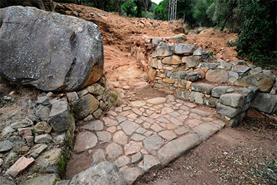
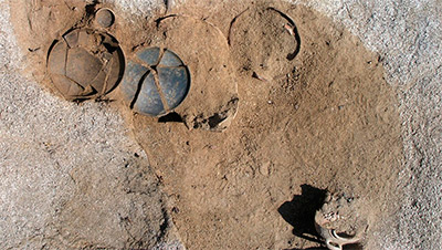
The Dos Pins necropolis excavated during 1986 and 1987, contains 94 tombs. The funerary loculi — always of cylindrical form and never wider than one meter in diameter — are dug into the bedrock. An Iberian amphora usually serves as the cinerary urn. The grave-goods are carefully arranged around it (see picture on the left). There is a basic homogeneity, within a range of differing typologies. This large necropolis seems to date from between the second half of the 3rd and the early 2nd c. B.C.E. A second necropolis at Can Rodon de l’Hort, with similar characteristics to Dos Pins — 14 known tombs, not yet fully excavated — was identified in 1888. It dates to between the end of the 4th and the early 2nd c. B.C.E. Both necropoleis were probably used to bury members of the local elite inhabiting the Burriac oppidum. Finally, at Can Ros, a much smaller funerary space — 5 graves concentrated in an area of less than 50 m2 — are known so far.
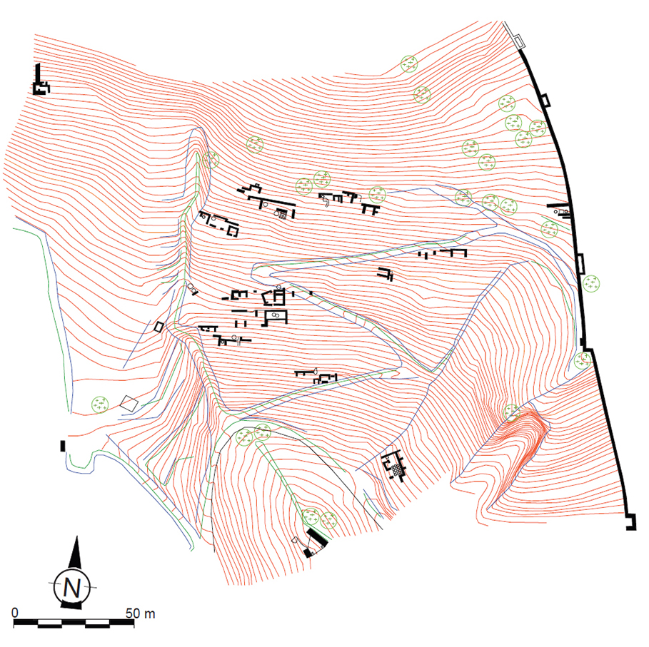
The Storage Pit Fields
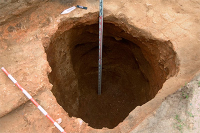
A number of scattered settlements, which must be related to the Iberian oppidum at Burriac, are located on the surrounding heights at a distance of no more than 800 m, with the southern gate at the center of this ring. On the communication axes represented by the current old town of Cabrera de Mar, there is a village stream and a second stream known as Torrente de Sant Feliu. Fields of storage pits are located on both sides of these communication axes, with significant examples at Can Borras, Ca l'Esteban, Ca l'Angusto, Can Bartolomeu, Can Miralles-Can Modolell, Camí de Can Segarra. The storage pit fields of Can Modolell-Can Miralles and Can Bartomeu, the most remarkable ones, were mostly filled with refuse or sediment during the last quarter of the 4th c. B.C.E. and 3rd c. B.C.E. There are two groups. The first - perhaps as many as 14 large pits - was filled in between the end of the 3rd c. and the early 2nd c. B.C.E. However, some pits, went out of use as grain stores and were filled earlier - during the 2nd half of the 4th c. B.C.E. -, while others were filled later, in the mid-2nd c. B.C.E. The second group - known as Can Bartomeu - is made up of 30 pits, 5 of which were filled during the 3rd quarter of the 3rd c. B.C.E., and a further 8 during the period when the two necropoleis were in use.
The content displayed on this page reproduces, with permission of the author and the journal, fragments of the following article: Sinner, A. G. “Cultural contacts and identity construction: a colonial context in NE Spain (2nd – early 1st c. B.C.),” Journal of Roman Archaeology 28 (2015) 7-37.
References:
- Banús, J. "Les Sitges del Poblat Ibèric de Burriac (Cabrera de Mar, El Maresme): Les Sitges Núms. 36 i 37. Noves aportacions sobre la fase final del poblat," Laietania 6 (1991) 57-83.
- Esteban, R., García, J., Pujol, J. "Les sitges del Poblat Ibèric de Burriac (Cabrera de Mar) (II)," Laietania 1 (1981) 15-63.
- García, J. "La necrópolis layetana del «Turó dels Dos Pins» (Cabrera de Mar)", In J. Blánquez y V. A. Del Val (coords.), Congreso de Arqueología ibérica: Las Necrópolis, Universidad Autónoma de Madrid. Varia 1 (Madrid 1991) 109-144.
- Garcia, J. Turo dels Dos Pins. Necropolis Ibérica (Barcelona 1991).
- García, J. and Zamora, D. "La vall de Cabrera de Mar. Un model d'ocupació del territori a la Laietània ibèrica," Laietania 8 (1993) 146-179.
- García, J. and Zamora, D. "Les necrópolis ibériques a Catalunya," In O. Mercadal (coord.) (ed.), XIII Colloqui Internacional d'Arqueologia de Puigcerdà: homenatge a Josep Barberà i Farràs, Puigcerdà, 14 i 15 de novembre de 2003, (Puigcerdà 2005) 955-970.
- Zamora, D. "L'oppidum de Burriac. Centre del poder polític de la Laietània ibérica," Laietania 17 (2006-2007) 1-417.